

From: The Guardian, Fri 14th Oct. 2022
For centuries the River Aller has been carefully controlled by the landowners and farmers of Exmoor, largely confined to a narrow channel and at one point squeezed under a medieval packhorse bridge.
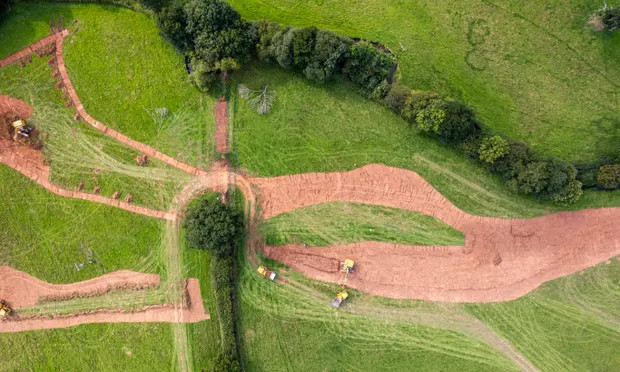
Now in a pioneering project, said to be a first for the UK and inspired by schemes in the wilds of Oregon in north-west US, a stretch of the river is being liberated, the channel partly filled in, allowing the water to spill out and find its own way, creating smaller streams, more pools and boggy areas.
The idea of this “Stage 0” restoration project is to create the conditions for a landscape that is better for flora and fauna, with the slower water flow making flooding less likely.
“We don’t really know how the site is going to react,” said Ben Eardley, project manager for the National Trust, which is leading the work at its Holnicote Estate in north Somerset.
“And we don’t know exactly what habitats will be created. We’re just re-setting it and we’ll see what happens. Stage 0 floodplain reconnection resets natural processes – it’s like the ‘ctrl, alt, delete’ computer reset. We let the river decide where it wants to go really but instead of that single channel there will be a much more complex waterscape, pools, wetland, marshy, boggy areas.”
Just under 1km of the main river and “bits and bobs” of tributary – nowhere near homes or roads – are the focus of the project. Diggers are taking a shallow skim off the floodplain, 4,000 tonnes worth, to re-shape the valley floor, and using that earth to fill in the channel.
The river is being given some help. About 600 tonnes of timber sourced on the estate from the felling of non-native trees have been pinned or partially buried into the valley to help the river’s transformation. “The timber will help kickstart some of that complexity,” said Eardley.
Wildflower seeds such as ragged robin, devil’s-bit scabious and meadowsweet will be sown over the next few weeks. And next spring about 25,000 native trees such as willow, bird cherry and black poplar will be planted. The hope is that this restored landscape will be better for wildlife including dragonflies, brown trout, grass snakes, birds, bats, water voles and otters.
The reset has been trialled on a much smaller scale on the estate, at a spot called Mud Pool Meadow, through which a tributary of the Aller flows.
It was launched in 2019 but Eardley said the results had been “amazing”. “Even in the very hot weather this summer the landscape held on to the water. You put your hand into the grass and it felt soft and wet. There’s not much noise in the surrounding fields but at Mud Pool Meadow there’s a cacophony of insect sound. There are grasshoppers exploding out of your footsteps, butterflies everywhere. It’s early days but you can tell it’s much richer and more abundant and diverse.”
Another significant project at Holnicote is the re-introduction of beavers, with seven of the mammals living in two large pens.
Beavers are seen by conservationists like Eardley as “ecosystem engineers” that develop wetlands by thinning trees and building dams. An intriguing prospect is that if the “Stage 0” restoration works well on the Aller and the UK government allows the release of beavers into the wild, it could be a perfect landscape for them to thrive in.
The Aller project is inspired by the Fivemile-Bell restoration scheme in Oregon, where work has been done on rivers and streams to restore them to how they were before settlers drained the land. One effect there has been to boost the number of salmon.
Prof Colin Thorne, the chair of physical geography at Nottingham University, said: “Around two dozen streams and rivers in Oregon have been successfully restored as complex and fully connected channel-wetland-floodplain systems known as Stage 0, producing remarkable benefits to river health, heritage, wildlife, sustainability and resilience.”
The National Trust is working on the Aller with a number of partners including the EU’s Interreg 2 Seas programme, the UK Environment Agency and Somerset Rivers Authority.
Cllr Mike Stanton, the chair of Somerset Rivers Authority, said he was excited by the Aller project. “It offers Somerset new possibilities for reducing flood risks, improving water quality and creating bigger and better habitats for wildlife. We must and will learn from this initiative with respect to other places in Somerset.”