Skip to content
DHWNEWS
Menu
  • Home
  • About
  • Contact
Menu

Poyle Data Centre proposal

Posted on February 3, 2025February 3, 2025 by ecwlarcombe

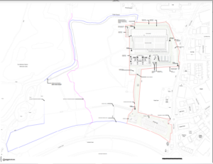
Please be aware of the Slough Planning Application for the new Data Centre at Poyle.  Drawing Number P/10076/013(2) locates the drawings.  It should be noted that the proposed development is just outside the RBWM boundary.  The development is vast and located immediately North of the Wraysbury Reservoir.

Recent Posts

  • Ashford Lane footbridge – simply rotten
  • Ashford Lane Footbridge – Failure analysis
  • Ashford Lane footbridge collapse – just the beginning?
  • Jubilee River footbridge collapsed (Number 10 – Ashford Lane).
  • The DRCCT and Datchet Parish Council

DATCHET

The name "Datchet" is thought to be Celtic in origin, and the last part may be related to cet ("wood"). In the Domesday Book it is called "Daceta".lla. Datchet is first mentioned between 990 and 994, when King Ethelred made small grants of land here.

HORTON

The village name "Horton" is a common one in England. It is Old English in origin and derives from the two words horu 'dirt' and tūn 'settlement, farm, estate', presumably meaning 'farm on muddy soil'.In the Domesday Book of 1086 it was recorded as Hortune.

WRAYSBURY

The village name was traditionally spelt Wyrardisbury; it is Anglo Saxon in origin and means 'Wïgrǣd's fort'. Its name is recorded in the Domesday Book of 1086 as Wirecesberie and as Wiredesbur in 1195. The name is seen again as Wyrardesbury in 1422.

©2025 DHWNEWS | Design: Newspaperly WordPress Theme