
Today the River Thames is rising and the Taplow flow control structure on the Jubilee River is being operated to divert flood water away from Windsor, Eton and Maidenhead. These actions affect water levels downstream. Today’s date happens to be 27/1/2026 and below is a record (a snapshot) of the graphical detail available at that time. Please note that if you follow the links below – the graphs will be different because time has moved on.
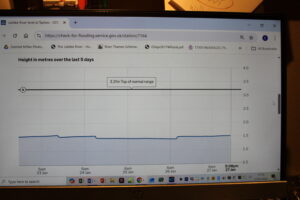
THE TAPLOW GAUGE
You will find that the gate movements at Taplow appear on the graph here
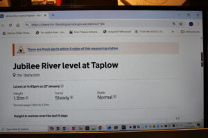
Please note that the gauge is upstream of the Taplow gates therefore the level drops as the gates are opened – and rises as the gates are closed. The effect on the graph height appears small but the change in increased (or reduced) volume conveyed can be large. Below records two gate openings followed by gate closure two days later.
The diverted flood water travels relatively quickly down the Jubilee River (because the channel is shorter, steeper and smoother) and re-enters the River Thames at the confluence in Datchet.
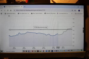
WINDSOR PARK
The Windsor Park gauge is located on the North bank of the Thames between the Windsor Road bridge and Datchet riverfront.
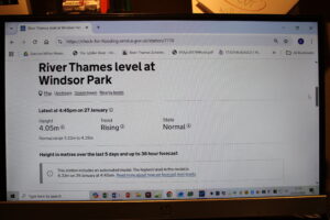
You will find that the gate movements at Taplow appear as definite ‘S shaped water level shocks’ on the Windsor Park graph here.
Finally – it is interesting to note that Taplow flow adjustments are also reflected on the Boulter’s Lock (downstream) and Maidenhead gauges. I have no doubt that operation of the Taplow flow control structure (i.e. gate adjustments) introduces water flow and level disruptions that are detectable and measurable a short distance upstream and many miles downstream.
Thank you for providing the information regarding telemetry in a way that the public may understand without complexity . Currently the River Thames is in a rising mode 28th Jan 26 , but within the normal range band . It is projected to rise just above this, dependent on expected rainfall within the coming days.