
This is the area flood warning map (including Datchet) published by Environment Agency.
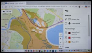
While the Environment Agency continues to operate the gates on the Taplow Flow Control structure (constructed nearly 25 years ago as part of MWEFAS) Datchet and other villages downstream are at increased probability of flooding. The footpath on Datchet Riverfront is already submerged and Wraysbury Village Green is showing signs of groundwater rise. Have a look at the flood warning map below. Where are the 80 new houses being built in Datchet? Where is the improved protection for 200 houses in Datchet as promised at the 1992 Planning Inquiry? Why is the Datchet Common Brook in desperate need of maintenance? Why is the Wraysbury Drain still blocked at Feathers Lane? What happened to the River Thames Scheme and the Datchet to Hythe End Flood Improvement Measures projects? Where has all the money gone? Have another look at the map – and then consider the future.