
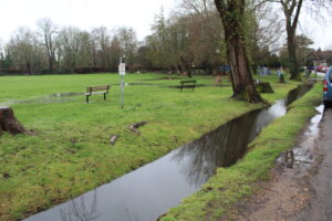
The upstream catchment is saturated. Local groundwater is rising and Wraysbury Village Green is being overwhelmed yet again. The image below is dated 7/2/2026, the ditch is full and rising flood water is clearly visible beyond the bench seats. More rain is forecast.
The villages of Datchet, Horton, Wraysbury and Old Windsor are situated downstream of the point at which the Jubilee River flood water in the parallel channel re-enters the River Thames. The threat of flooding is here yet again – local land drainage infrastructure is either blocked solid or lacks maintenance and any costly new flood defences are still a figment of somebody’s imagination. In 2019 I informed the authorities that the Wraysbury Drain was blocked. It is now 2026 – and the Wraysbury Drain is still blocked. The RTS and DHEFIM projects are stalled.
Notes: £100m+ spent to date on RTS project development. Wraysbury Drain is an ancient watercourse that dates back to pre-1799. The local ground sits on a bed of glacial gravel. The Jubilee River is the main element of the MWEFAS that was opened in 2002.
Taplow flow control structure gate adjustments on the Jubilee River can be seen here and the downstream effect recorded about 2 hours later here